Trail Walking La Motte-du-Caire - Le sentier de démonstration  - La Motte du Caire - Photo

Le sentier de démonstration - La Motte du Caire

 tracegps
tracegps

User

© OpenStreetMap contributors
Length
Length
6.6 km
Max alt
Max alt
815 m
Uphill gradient
Uphill gradient
121 m
Km-Effort
Km-Effort  
8.2 km
Min alt
Min alt
703 m
Downhill gradient
Downhill gradient
121 m
Boucle
Boucle
Yes
Creation date :
2014-12-10 00:00:00.0
Updated on :
2014-12-10 00:00:00.0

(0 Reviews)

Walking
Walking
2h30
Difficulty : Medium

Scan this QR Code to open this trail in the SityTrail application

FREE GPS app for hiking

Logo SityTrail SityTrail

IGN / Geographical institutes

Download SityTrail from the App Store Download SityTrail from Google Play

Logo SityTrail SityTrail World

The world is yours!

Download SityTrail from the App Store Download SityTrail from Google Play Download SityTrail on Huawei AppGallery

About

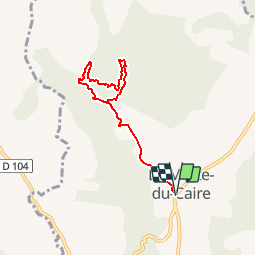
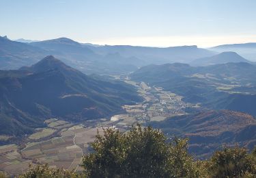
Trail Walking of 6.6 km to be discovered at Provence-Alpes-Côte d'Azur, Alpes-de-Haute-Provence, La Motte-du-Caire. This trail is proposed by tracegps.

Description

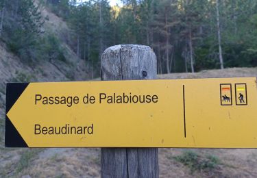
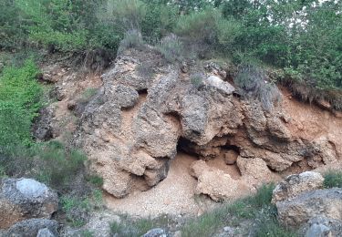
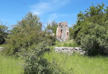
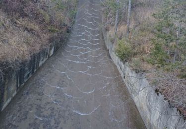
Départ de la place de La Motte du Caire. 10 bornes jalonnent ce circuit en ayant pour thème principal «la restauration forestière durant un siècle afin de lutter contre l’érosion de marnes» (document pédagogique réalisé par le CEMAGREF et l’ONF à disposition à l’office de tourisme). De la place du village, remonter le ravin de Saignon jusqu’au barrage du même nom. Poursuivre cette piste en direction du sommet des Croix. La jonction avec une nouvelle piste vous oblige à laisser sur votre gauche celle conduisant à la ferme du Saignon. De ce fait, et après avoir franchi les bornes 5 et 6, revenir sur la piste de droite pour l’emprunter sur plus d’un km. Un sentier à droite va vous conduire jusqu’à la retenue du Saignon que vous traversez afin de rejoindre la première partie de votre circuit. Le retour à la Motte du Caire va se faire par la même piste d’accès au barrage.

Elevation profile

Photos

Positioning

Country:
France
Region :
Provence-Alpes-Côte d'Azur
Department/Province :
Alpes-de-Haute-Provence
Municipality :
La Motte-du-Caire
Location:
Unknown
Start:(UTM)
263062 ; 4914256 (32T) N.

Trails nearby

Trail Walking Clamensane - Clamensane - Col de la Croix - Chapelle St-Amand - Photo
Walking
GUIDE
Marco05

Walking

Medium
(1)
Clamensane, Provence-Alpes-Côte d'Azur, Alpes-de-Haute-Provence, France
12.7 km | 22 km-effort
5h 0min
Yes
Trail Walking Clamensane - CLAMENSANE.  TROU DU DIABLR  . CHAPELLE S AMAND . COL LA CROIX . O L M S. IX  - Photo
Walking
RobinMicheline

Walking

Difficult
Clamensane, Provence-Alpes-Côte d'Azur, Alpes-de-Haute-Provence, France
12.5 km | 21 km-effort
3h 27min
Yes
Trail Walking Clamensane - VALAVOIRE  Pas de Palabiouse , bergerie de Premarche o l s  - Photo
Walking
RobinMicheline

Walking

Difficult
Clamensane, Provence-Alpes-Côte d'Azur, Alpes-de-Haute-Provence, France
11.7 km | 22 km-effort
3h 53min
Yes
Trail Walking Clamensane - VALAVOIRE.  Pas de Palabrouse.  Fontaine de  Pouille o l s - Photo
Walking
RobinMicheline

Walking

Medium
Clamensane, Provence-Alpes-Côte d'Azur, Alpes-de-Haute-Provence, France
11.9 km | 19.8 km-effort
3h 50min
Yes
Trail Walking La Motte-du-Caire - LA MOTTE DU CAIRE .Le tour de la Blachere o - Photo
Walking
RobinMicheline

Walking

Difficult
La Motte-du-Caire, Provence-Alpes-Côte d'Azur, Alpes-de-Haute-Provence, France
37 km | 67 km-effort
4h 0min
No
Trail Walking Melve - 20191126_Melve Tête de Boursier - Photo
Walking
PapouBertrand

Walking

Medium
(1)
Melve, Provence-Alpes-Côte d'Azur, Alpes-de-Haute-Provence, France
8.7 km | 16.4 km-effort
5h 5min
No
Trail Walking Melve - Melve Rando Pivoines, avec la RSPG : https://www.rspg05.org/ - Photo
Walking
Daniel.BRUN-PICARD

Walking

Medium
Melve, Provence-Alpes-Côte d'Azur, Alpes-de-Haute-Provence, France
8.3 km | 16.4 km-effort
5h 13min
No
Trail Walking La Motte-du-Caire - Rome-36-LaMotteDuCaire-Tallard-20170905 - Photo
Walking
patrickdanilo

Walking

Difficult
La Motte-du-Caire, Provence-Alpes-Côte d'Azur, Alpes-de-Haute-Provence, France
22 km | 33 km-effort
6h 41min
No
Trail Walking Clamensane - La chapelle St Amand - Clamensane  - Photo
Walking
tracegps

Walking

Very difficult
Clamensane, Provence-Alpes-Côte d'Azur, Alpes-de-Haute-Provence, France
12.7 km | 22 km-effort
4h 30min
Yes


Close
My subscriptions